

shiuly-suherni-gJiZdWCaLJc-unsplash

Spotlight Research

Summary and Analysis:

Estimating pedestrian demand for active transport evaluation and planning

Keywords

This article presents a recently developed walkability-based approach to evaluating the built environment’s relationship to pedestrian activity, as well as the application of this evaluation in generating a model of pedestrian demand across London derived from built environment indicators. The approach is novel in its integration of space syntax measures to evaluate network accessibility and the use of volume area ratios to measure land use intensity. It utilises high-resolution geographic data surfaces for the generation of the built environment variables. The advantage of using this method is that it allows greater analytical flexibility in transport policy and practice, where the ability to compare the analytical results to other social and spatial indicators is vital for decision-making. Pedestrian density data covering the whole of Greater London are used to test the performance of the variables. The best performing variables are then analysed to determine their weighting in a model of pedestrian demand for London based on the selected built environment indicators. Randomised testing shows that the model is capable of reliably predicting pedestrian demand. It can be used to estimate pedestrian demand both currently and for future scenarios by quantify future changes to the built environment, and thus enabling walking to be quantitatively assessed in the same way as motorised modes. The model can be applied to active travel infrastructure planning and policy evaluation, from the scale of the street or intersection, to larger administrative units. The model also has wider theoretical and policy implications that relate to the spatial structuring of London.

Summary and Analysis

View support quotes and references at the bottom of the page.

Overview of Research Area

Urban environments are increasingly shaped by the need to reconcile mobility efficiency with public health outcomes. Walking has become a central concern of both transport planning and urban design, not only because it is a mode of movement, but because it is tied to physical activity, accessibility, social inclusion, and environmental sustainability.

Despite this importance, pedestrian movement remains surprisingly difficult to model at the scale of the city. Conventional transport models have often prioritised vehicular flows, while pedestrian behaviour is treated as secondary, fragmented, or locally observed. In practice, this means that walking is frequently studied after the fact, through counts, surveys, or site-based observations, rather than as a system that can be anticipated in advance. That creates a gap between planning intent and actual movement behaviour, and it limits how seriously walking is treated in urban decision-making.

Space syntax offers an alternative approach by reframing movement as a property of spatial configuration rather than solely individual choice. In this framework, the street network is not a passive surface but an active system that structures movement through relational connectivity. Streets with higher levels of integration within the network tend to attract greater pedestrian flows, not because of their immediate land use alone, but because of their position within the system as a whole. Bill Hillier set out this argument fully in Space is the Machine.

This is one of the reasons space syntax remains useful, and also contested. It offers a powerful way of reading urban form, but it can also become overconfident in what it claims to explain. Dhanani, Tarkhanyan and Vaughan extend the framework through empirical modelling of pedestrian movement in London, demonstrating that spatial configuration can be used to estimate pedestrian demand with measurable accuracy. The value of the paper lies not only in that result, but in the way it reconnects configurational theory to contemporary transport evaluation.

Why is this Research of Interest?

This research matters because it gives a predictive role to pedestrian movement. In many planning contexts, walking is still handled through aspiration or broad policy goals, rather than through robust quantitative estimation. This work offers a way to think about pedestrian demand in the same modelling conversation as other transport modes.

From a space syntax perspective, this is especially useful because it preserves one of the field’s key insights while grounding it in applied planning. The paper shows that network accessibility matters, but it also demonstrates that accessibility alone is not enough. The built environment has to be evaluated through the combination of spatial configuration and land-use intensity, not one or the other in isolation. That is an important correction to overly simple walkability claims.

The paper is also interesting because it is not satisfied with correlation as a final answer. It develops a model, tests its performance, and then uses that model to suggest how future scenarios could be evaluated. In other words, it turns a spatial analysis into a planning tool. That matters because it gives planners a way to compare interventions before they are built, and to assess whether a proposed change will shift pedestrian demand in a meaningful way.

At the same time, a critical reading is necessary. The strength of the model is also its limitation. By translating pedestrian activity into a quantifiable estimate, it necessarily abstracts away some of the qualities that shape walking as lived experience. A street can produce high demand without being pleasant. A route can be efficient without being comfortable. So the paper is powerful, but it is not the whole story.

  1. It shows that pedestrian demand can be modelled in advance.
  2. It demonstrates that spatial structure and land use together shape pedestrian activity.
  3. It exposes the gap between measurable demand and experiential quality.

That gap is where a broader design reading becomes necessary.

What are the Findings of this Research?
  1. Pedestrian demand in London can be estimated from spatial and built-environment indicators

The core finding is that pedestrian demand in London can be estimated using a model built from spatial configuration and built-environment indicators. The paper identifies a set of variables that best explain observed pedestrian density, then uses those variables to construct a predictive model that performs reliably under randomised testing.

  1. Network accessibility shapes movement at the level of the whole system, not just the street

The spatial dimension is central. The research uses space syntax measures to evaluate network accessibility, which means the street network is treated as a relational structure rather than a set of isolated segments. This is important because it allows the model to account for how a street’s position within the wider network influences pedestrian activity. A highly connected street is not just locally busy. It is part of a larger pattern of accessibility.

  1. Land-use intensity adds a second, necessary layer

Land-use intensity is the other major component. The paper uses volume-area ratios as a way of measuring built-environment intensity, which provides a more nuanced account of land use than simple zoning labels. This allows the model to capture whether a place is genuinely dense in activities and destinations, rather than merely designated as mixed use in planning terms. That distinction matters because pedestrian movement is influenced by what is actually present on the ground, not by planning category alone.

  1. The model performs reliably under testing and extends to future scenarios

The model is tested across Greater London using pedestrian density data. The result is not merely descriptive. The study shows that the model can reliably predict pedestrian demand and can be used to estimate future demand under different built-environment scenarios. This is one of the most useful aspects of the paper because it means that walking can be evaluated in a way that is closer to how motorised transport is often assessed.

Taken together, these findings establish that pedestrian demand is not random but patterned by the built environment, that spatial configuration matters because it conditions how land use performs, and that the resulting model can support planning at multiple scales, from street level to larger administrative areas.
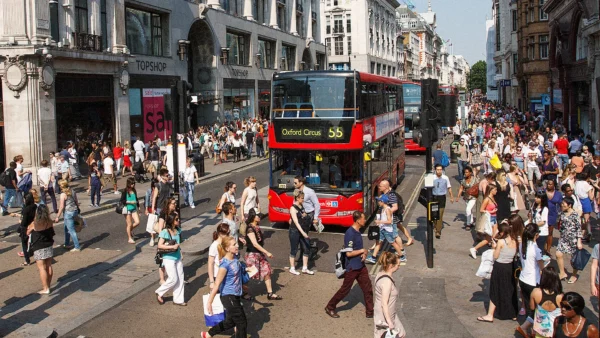
Oxford Street - active pedestrian + frontage
Oxford Street – one of the busiest streets with visible pedestrian activity and active frontage

A Note on the Data: 

The paper is methodologically strong because it works with high-resolution geographic data surfaces and uses them to build built-environment variables that can be tested against observed pedestrian density. This means the model is not built from broad assumptions, but from spatially detailed data that reflect the structure of London as an actual city.

The data can be understood in three layers:

  1. Spatial configuration data – These are the space syntax measures used to evaluate network accessibility. They describe how the street network is structured and how accessible different places are within it. This is the main structural layer of the model.
  2. Land-use intensity data – The paper uses volume-area ratios to measure the intensity of built form and land use. This helps move beyond crude land-use categories and gives a better sense of how active or dense a place is in functional terms.
  3. Observed pedestrian density data – These data are used to test the model’s performance across Greater London. They ground the analysis in actual movement and make it possible to compare prediction with observed demand.

For London, the data conversation becomes richer when the paper is read beside other city datasets that capture health, comfort, and sensory experience.

  1. Healthy Streets is useful because it frames streets in terms of how they support people rather than vehicles. Transport for London’s Healthy Streets approach includes indicators such as air quality, shade, shelter, safety, and things to see and do, which makes it a valuable complement to movement modelling (Transport for London, Healthy Streets).
  2. Noise mapping adds another layer of urban reality. London road traffic noise maps show how acoustic exposure varies across the city and how traffic corridors generate strong gradients of sound pressure (NoiseMap, London Road Traffic Noise Map). That matters because noise shapes comfort, route choice, and the willingness of a street user to linger, even if it does not always appear directly in movement models.
  3. Air quality mapping is equally important. The London Air Quality Network provides maps and monitoring for pollution across Greater London, including data on pollutants that affect health and street-level experience (London Air Quality Network, Pollution in my area and London Air Quality Network). A street can be highly integrated and still be unpleasant to walk in if exposure levels are high.
  4. Smell mapping introduces a more subjective but equally important sensory dimension. Kate McLean’s sensory mapping work shows how smell can be used to chart urban atmospheres shaped by food, traffic, waste, vegetation, and weather (McLean, K., Sensory Maps). Smell is rarely included in formal transport modelling, but it can strongly affect memory, attraction, and avoidance.

Taken together, these datasets suggest that a street can be structurally strong in movement terms while still performing unevenly in health, comfort, and sensory experience. Spatial configuration explains where movement is likely to happen, but these London datasets help begin to explain how that movement is felt.

Street Scores

Street Scores is a playful extension of the analysis rather than a formal method. I invite any pedestrian or street user to choose the variables they would use to judge a street and then assign it a score based on their own perception. The point is not to standardise judgement or produce a single correct result. Instead, it creates a light, participatory way of thinking about how streets are experienced.

A street user might judge a street on comfort, calmness, safety, beauty, vibrancy, cleanliness, or even a more personal or humorous criterion. One person might care most about noise, another about shade, another about how walkable a place feels, and another about whether it has good people watching. The score becomes a conversation starter rather than a scientific metric. Try it here: Street Scores

The value of the idea is that it opens up an informal comparison between modelled pedestrian demand and lived judgement. A user might score a street for calmness, safety, beauty, shade, social energy, or just general vibe. The result is not meant to be a scientific measure. It is a way of surfacing how differently streets can be experienced.

The streets that the model predicts as strong in movement terms may not be the streets that people enjoy most. The score can then be compared informally with the structurally predicted pedestrian movement derived from space syntax. What may emerge is not a neat alignment, but divergence. Some streets will perform very well in movement terms but feel unpleasant, intense, or stressful. Others may attract fewer pedestrians but be perceived as pleasant, calm, or socially attractive.

This divergence is what I hope makes the idea interesting. It may reveal   that urban space can be successful in one register and unsatisfying in another. Street Scores may not try to resolve that contradiction but  treat the mismatch as the point, because that is where design judgment becomes most revealing.


How do the Findings Relate to the CCD's Designing for Life Themes?
  1. Health & Wellbeing. The research links pedestrian movement to conditions that affect daily health, comfort, and exposure. Walking is not just a transport output here. It is part of the environmental and bodily conditions that shape everyday urban life.
  2. Safety & Security. Street form, connectivity, and perceived safety shape whether people move through space confidently and consistently. A street that performs well in network terms may still feel unsafe if noise, traffic, or poor environmental quality make it difficult to inhabit comfortably.
  3. Comfort & Accessibility. The paper shows that efficient movement is not the same as good experience. That distinction is important because accessibility is not only about getting through space, but about doing so without unnecessary discomfort, stress, or exclusion.
  4. Agency & Autonomy. This is relevant if you want to stress choice and route selection, although it is less directly supported by the paper than the first three themes. It becomes useful when thinking about whether pedestrians can choose between routes that differ in comfort, legibility, or sensory quality, and whether street environments genuinely support that choice.

A critical reading is important here. Space syntax is often strongest when it is used to explain broad urban tendencies, but weaker when it is asked to account for everything at once. That is not a flaw so much as a reminder of scale. Configuration can describe one layer of urban reality very well. It cannot absorb every experiential, political, or cultural dimension without becoming overly elastic. The value of the method lies in its clarity, but that clarity should not be mistaken for total explanation.

How Can Insights from this Research be Applied to Design?

The research has clear planning value because it shows that pedestrian demand can be estimated before intervention. That makes it useful for evaluating proposals, comparing scenarios, and identifying where walking is likely to be supported or underprovided.

Design practice can use this in several ways:

  • Location of active uses – Retail, services, and other active uses should be located where network accessibility is strong, because spatial configuration amplifies their effect.
  • Scenario testing – Before streets are redesigned or developments are built, planners can estimate how changes in the built environment may alter pedestrian demand.
  • Cross-scale evaluation –The model can work from street and intersection scale up to larger administrative units, which makes it useful for both local design and city-wide planning.
  • Complementary qualitative tools – Tools like Street Scores can be used alongside quantitative modelling to highlight where demand and experience diverge.

The broader lesson is that pedestrian movement should be treated as something designed, not just observed. But the design conversation should include both structural performance and street-level experience. That is where the paper becomes most useful.
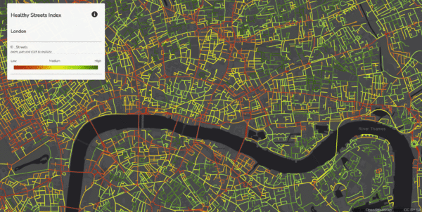
A Healthy Streets map of London


Dhanani, A., Tarkhanyan, L., and Vaughan, L. (2017). Estimating pedestrian demand for active transport evaluation and planning. Transportation Research Part A: Policy and Practice, 103, 54–69. https://doi.org/10.1016/j.tra.2017.05.020

Hillier, B. (1996). Space is the Machine. Cambridge University Press. https://discovery.ucl.ac.uk/id/eprint/3881/

Hillier, B., and Hanson, J. (1984). The Social Logic of Space. Cambridge University Press. https://doi.org/10.1017/CBO9780511597237

Transport for London (n.d.). Healthy Streets. https://tfl.gov.uk/corporate/about-tfl/how-we-work/planning-for-the-future/healthy-streets

NoiseMap (n.d.). London Road Traffic Noise Map. https://www.noisemap.ltd.uk/projects/london%20noise%20map/london%20noise%20map.html

London Air Quality Network (n.d.). Pollution in my area. https://londonair.org.uk/map-maker/

London Air Quality Network (n.d.). London Air Quality Network. https://www.londonair.org.uk

McLean, K. (n.d.). Sensory Maps. https://sensorymaps.com

To continue reading...

Join and experience more as a Member

  • Access all our publications
  • Attend our events and access recordings
  • Offers from Partners in our network
  • Support the Conscious Cities movement!
  • Receive updates on new content and events

Access all our publications

Attend our events and access recordings

Offers from Partners in our network

Support the Conscious Cities movement!

Receive updates on new content and events

Cancel any time